Rather than going to a big time reunion on campus, Hannah and I have come to western New York for a mini-reunion with three of her College of Wooster (Ohio) dorm mates from the class of 1970.
A few years back the idea for the four women getting together crystallized to the point that last year Hannah offered our place in York, Maine for the First Annual Woo Girls Reunion.
Wendy, Bambi, Hannah, and Maxine
Here’s the Line-up of the Four Women of Wooster:
Hannah – All she is cracked up to be!
Maxine – Hannah’s roommate during their sophomore and junior years who remains as upbeat and positive as I remember her when I was a classmate of hers.
Bambi – the life of the party at Wooster who to this day brings joy wherever she goes.
Wendy – the steady rock who is the glue that brings us all into conversations and makes us all feel like we belong.
You may have noticed that I referred to myself as a classmate, not as a fellow graduate of these four women. You see, though I matriculated with them as a freshman in the fall of 1966 at the liberal arts College of Wooster, I transferred out after my junior year to Arizona State University to be an elementary education major.
You might be thinking, whoa, something must have come up for him to jump ship just before his senior year. Well, it’s complicated.
First, after a rocking year of dating during our sophomore year, Hannah and I hit the skids during our junior year. Going to the Desert Southwest was my response to a broken heart.
Second, I was a political science major! Please! What in the world does one do with a political science degree? At Wooster all I thought it was going to do was prepare me to be a salesman for Proctor and Gamble (as my teammate on the Wooster tennis team did) or go to grad school. After 21 years of being a student, I was so sick of sitting in classrooms. Grad school was the farthest thing from my mind.
Third, in light of #2, I wanted to make a difference. This was the dawning of the Age of Aquarius. Peace and love, man. For me, that meant give teaching a shot.
Fourth, I was sick of the snow and the rain of central Ohio; the Arizona sunshine looked awfully appealing. I would then be just one state away from doing some California Dreamin’.
Fifth, this was May of 1969. The War in Viet Nam raged and shattered the lives of so many. I had just one year before my day of reckoning with the Selective Service drew nigh. Unbeknownst to me, six months later I would draw number 78 out of 365 in the first televised draft lottery. With my college deferment up and the military drafting guys with numbers up to 195, it was clear my future was not clear one bit, with the sword of Damocles hanging over my head.
Sixth, I just never adapted to Wooster. That’s on me, not Wooster. I was kind of aimless. Duh, I was a political science major! I loved being a part of Wooster’s tennis team. Sophomore year with Hannah was off-the-charts. But college classes? The traditional lecture method of teaching that reigned at Wooster was killing me. I needed hands-on, experiential, conversation-based teaching. After years at Wooster, all I could do was study, test, and forget.
Hannah with two friends
And yet now years later, I think of the College of Wooster as the best thing that ever happened to me.
You see I met and Woo-ed Hannah Kraai.
Married to my own Woo Girl, I joined her in Niagara Falls with three of her classmates in mid-June of 2016.
Hannah and I have come to New York to spend the weekend in Ithaca with our son Will and his wife Laurel. While the others sleep in this Saturday morning in late April, I awake to begin my Daily Morning Routine: an hour of stretching and meditating. Ommmmm. You see, at the age of 68, years of casual inattention to my posture and overall poor body flexibility have finally caught up with me.
Owen (3 5/6) supporting Max as Max turns 2
You see, four weeks ago, I picked up our grandsons Owen and Max while they stayed with us for four days while Molly and Tip went hiking in Zion National Park. By the fourth day I awoke with a stiff neck. Unable to move my neck right or left without pain, I sought out my friend/physical therapist, Corky Thomson, for some relief.
While reasonably healthy with decent cardio fitness, I have the flexibility of a dining room chair. It seems that my lack of flexibility was an accident waiting to happen; it wasn’t just lifting the boys but years of neglect to maintaining my flexibility. Amazing how the pain and the possibility of not being able to be physical active (especially to play Pickleball) gets my attention and calls me to wake up and smell the coffee.
Sadie supporting me during my morning stretching
After learning stretching exercises with Corky, I begin each day with neck and shoulder stretches, arms and legs stretches. Amazingly within a week of her instruction and my commitment, I am indeed more flexible. It’s becoming my yoga, my California Mellow. I get it that I have a lifetime of such morning stretching ahead.
Will and Laurel at Taughannock Falls
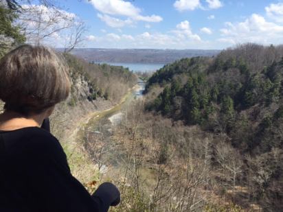
Ithaca, New York is blessed with fantastic waterfall hiking at its doorstep. On previous trips to central New York, with Will and Laurel, Hannah and I have hiked the Buttermilk Falls and Treman State Park Trails right in town. (Go to the categories link to the left of this blog, then click on New York Ithaca area to read those blogs.)
It’s a twenty-minute drive from their place to the southern reaches of their own personal Finger Lake, Cayuga. Today we’ll hike in Taughannock Falls State Park (pronounced Ta-gan-ick). On this last day of April, we have two distinct hiking advantages. One, the park is happy with people but not mobbed. Two, the trees have not leafed out so we can see views from above to the Taughannock River and later to the Taughannock Falls themselves that we wouldn’t see in May.
Parking at the trailhead is limited to 30 cars, but across the street there are many more spaces. Beginning the climb to the gorge rim on granite steps, we find the climbing easy and invigorating. Pairing off, Hannah talks with Will in front while I talk up our daughter-in-law Laurel. We’ve hiked and spent so much time with Laurel over the past few years that the conversation flows and life is good when your child marries well.
Very shortly, we are at the top of the gorge on the South Rim Trail, paralleling the cliff to our right. At the rim the hike is on level, hard packed dirt, such that our nearly four-year-old grandson Owen could hike most of it while his two-year-old brother Max would not be far behind.
Rocking along the wide trail we come to an overlook to check out the Taughannock River below. The 52F morning of bright sun makes it shorts weather. The South Rim goes past the 215 foot falls nearly two miles from the trailhead to a walking bridge that crosses to the other side. At the turnaround we are at a country road parking area that allows folks a full view of the waterfall, no matter how little or much they want to hike.
Hannah on the Rim Trail looking out to Cayuga Lake
Hikers are protected at the steep sides of the gorge by four-foot fencing on a trail that today can only be described as delightful. At the falls, we descend some 30 feet to a full frontal view of the Taughannock Falls. Here at the falls, there is again ample parking for folks who just want to take in the view.
Paired off again, we four descend the descending trail back to the trailhead. Nearly four miles after our start, we arrive back at the river bottom.
From this point at the trailhead, we now head on the nearly level twenty-foot-wide Gorge Trail along the river to the base of the Taughannock Falls. The Gorge Trail is far busier than the Rim Trails but in an early spring way. Walking three quarters of a mile to the falls we are dwarfed by the high slate and shale cliffs above us.
Crossing the river, we are within 200 yards of the end of the trail. There we are happily rinsed by the mist from the falls. This video captures the falls in action.
The gentle walk back to the trailhead ¾ of a mile away gives us a six-mile morning of hiking joy.
By the way, you may have noticed a blue elephant in some of our pictures. Having forgotten Owen’s stuffed animal Woodstock, we have at least brought Max’s Blue Elephant to travel with us as our Flat Stanley (click on this link to learn more about the young man of children’s literature) to document our travels.
Parents with school age children will know Flat Stanley (a cardboard cutout) as a young man who sees the world and has his picture taken at the various spots when his handlers (anyone who travels) see the world. We plan to take Woodstock and Blue Elephant to the waterfalls, mountaintops, and bluffs of these our United States to take a part of Owen and Max with us when we travel.
As a student teacher in fifth grade in the spring of 1970, I would walk from my Irish Hall dorm on the campus of Arizona State University to Mitchell School in Tempe, maybe a distance of a mile. I had no car and it was always sunny. I literally mean, it was always sunny for the entire semester in the Desert Southwest that spring semester. Our students had outside recess EVERY day.
As ones who lived for ten years in the Valley of the Sun (Phoenix Metro area), Hannah and I were used to a steady diet of 100+F degree days from the first of May until October. Day in and day out for those five months, we could count on lows in the 80s or 90s and highs always above 100F, often well above. It was not pretty. The summer weather is as consistent in the Southwest desert as a Steph Curry three pointer.
Weather consistency is not the case in our adopted state of Maine. Yesterday my UNH college buddy, Bill and I climbed the Beehive Trail at Acadia National Park in shorts and tee shirts in 68F of delightfulness. (See the list of categories to the left of the blog, click on Acadia National Park, and voila yesterday’s Beehive hiking blog will appear.)
Bill from Au Canada at Jordan Pond as our ride begins
This late April morning Bill and I wake in Bar Harbor to light rain with a freshening wind that puts a chill in the air. Welcome to the variability of Maine weather as today I will bike on the Carriage Roads of Acadia National Park on Mount Desert Island in zipoff pants, heavy sweatshirt beneath my jacket with Thinsulate gloves.
Carriage Road of Acadia National Park
Leaving our Best Western Acadia Park Inn after the morning rain abates at 930A, we drive the Park Loop Road past Eagle Lake and Jordan Pond without seeing another car. Though National Park Service has added parking to the Jordan Pond area, we have no problem finding a parking spot right in front of the classic Jordan House this preseason April.
Bundled up in late April
Unloading the bikes, Bill and I bundle up against the cold. Within two hundred yards, we are pedaling on the Carriage Road towards Jordan Pond itself. The downhill coasting we do at the outset belies what awaits us as we soon will make our way around the mountain.
Jordan Pond from the Carriage Road
Paralleling Jordan Pond on the road, we ride side by side on the 16-foot-wide hard packed gravel Carriage Road with a steady climb. What must be annoying for Bill, I stop to take pictures as he pedals on. As a Canadian, he fits all the stereotypes: he’s a genuinely good guy, understanding, thoughtful, not full of himself, and he knows I’ll eventually catch up.
The signage is excellent for the Carriage Roads and especially for the “Around the Mountain” (i.e., Sargent Mountain) Loop that we will take. At sign marker 10, we head left and begin to climb as our pedaling becomes more labored. Thank heaven for my 21 gears and a winter of rocking the recumbent bike at our Coastal Fitness gym.
Mountain Bill on the far side of the mountain
As a steady, slow grind up the mountain, our conversation ceases. The name of the trail is “Around the M0untain,” but we become mountain climbers this still chilly morning. Soon my body produces heat as if I’m fueling a 1800s locomotive up over the Rockies; in time I de-bike and pack my jacket on my bike rack.
The day is raw and overcast with sprinkles here and light rain there as we are high above Frenchman’s Bay. But there is no getting around the beauty of the setting, especially without the chaos of the summer season.
Justly rewarded with a downhill, I ride the brakes lightly as the hard packed gravel is, well, still gravelly and could give way with a quick turn. We pass an athletic female runner with a Camelback water bag, then later a mountain racer zips by leaving us in the dust.
Somes Sound
The winding trail takes us high above Somes Sound with views to the mountains to the south and the Atlantic Ocean to the east. Descending easily on this dream ride, I put my gloves and jacket back on. Passing over many of Rockefeller’s stone bridges made from local granite, we later learn that the park has sixteen Carriage Road bridges that cross ravines or the motor routes through the park.
Waterfall of Waterfall Bridge (look hard, it’s there)
Soon we come upon another bridge and hear voices. Stopping to investigate, we spot the waterfall at the appropriately named Waterfall Bridge. Built in 1925, the Waterfall Bridge, which spans Hadlock Brook, is 125 feet in length and flares at the ends. A pair of viewing platforms jut out on either side to take advantage of the view.
Selfie of two UNH Wildcats at the waterfall
Upon returning to the Jordan House parking lot, we have had a 20 kilometer (12 miles American) ride “Around the Mountain” at a slow and steady pace over the past nearly two hours of spring chill on the coast of Maine. Finished with our ride, we head into town to explore and perhaps discover why the town is called Bar Harbor. And soon we will indeed find out why.
The view from Bridge Street in Bar Harbor to Bar Island
Seeing on our Acadia National Park Hiking and Biking Trail Map ($4.95 at the Visitor Center) that there is a trail from town to Bar Island just off shore, we work our way to Bridge Street. There we see a concrete ramp sloping into the bay, with Bar Island, maybe 400 yards in the distance. The tide is in and there is no way we are crossing without a boat. What gives? Where the h is the trail?
The rocky sand bar from Bar Harbor to Bar Island
Fortunately, an Anglo Rastafarian (perhaps I’ve jumped to that conclusion because he has dreadlocks) comes by and notices our perplexity. He tells us that for an hour and a half or two on either side of low tide, there is indeed a road to Bar Island that cars and walkers can cross. But once the tide comes in, one is stuck on the island for 8+ hours unless one wants to wade through what must be 40-degree water today.
Once called Eden, the town’s name was changed to Bar Harbor in 1918 because of the sand bar that goes to Bar Island. Bill and I light up with the possibility of exploring this island when we next visit; ever mindful of the low and high tides.
It’s been three weeks since we returned from Connie Pike’s Voice Rehabilitation Clinic in Apollo Beach, Florida. Here is Hannah in her own words:
….since we left Florida I’ve (re)discovered ed a few things.
1. Progress/rehab is a slow, steady process….just like ANY rehab.(I remember with my broken leg four years back.) It does not happen overnight, over the weekend, or even in a month’s time. Baby steps. “Patient, gentle persistence,” as my sister said on the phone the other day. It helps if I remember all of the above when I might be wishing for “grander” progress in such a relatively short time.
2. I’ve been trying to spread my “practice” throughout the day….always try to start the day with 15-20 minutes of whatever (word lists read while balancing on the ball, stretching, breathing, etc.) Connie reminded me that little bits throughout the day are more effective than one or two bigger sessions. Makes sense to me. Besides, sometimes the “exploration” can be a bit exhausting.
3. I find I do a lot of humming of songs in the car. Kazooing too. It’s a good use of my time in the car (though I do miss listening to my CDs and NPR!)
4. On the way home from FL, I listened to a commencement address by Susan Sandberg (Stanford.) Something she said in it was very helpful to me.
Her husband Dave had died a year prior. She was confiding to a friend that “she just wanted Dave.” Her friend reminded her that that option (Plan A) was no longer available. And, that same friend suggested, “Why don’t we just kick the sh*t (sorry!) out of Plan B?”
I found myself thinking that my “former voice” was Plan A. I think of this new path I’m on with my voice as “Plan B.” And, I do plan to do just what Susan’s friend suggested…
Hoping your plan, whatever it is, and however you are implementing it, is taking you good places – places you may never have otherwise gone before. love, Hannah
Fear and trust. It’s time to leave the former for the latter. I mean, how is fear working for you? We all have choices. The transition from fear to trust and faith begins by believing. Each morning I read through my affirmations. The very first one is This is the best time in my life as I am more trusting and have greater faith. Trusting has taken a boatload of practice for me to make it come more naturally. In dealing with challenges, be they with people, situations, or physical, trusting in myself has made all the difference.
Beehive Mountain at Acadia National Park
Coming north from our home in York, Maine to Acadia National Park, I am ready to trust and face my one-time belief that climbing the Beehive Trail was beyond me; too risky, too too. With its vertical rungs of rebars, the Beehive Trail, I imagined, was for those far more adventurous than I.
People may point to the fact that a young woman died climbing a similar vertical park hike (Precipice Trail) in 2012. So? Hundreds, thousands have successfully climbed the Beehive Trail. Why make an outlier a guide for life? Another of my morning affirmations (really my philosophy of life) is I don’t assume lightning will strike when I make decisions.
MDI, home to Acadia National Park along the coast of Maine
The small crack to trust that I could climb the Beehive Trail was born on Angel’s Landing in Utah. If I could climb that peak in Zion National Park, why not the Beehive Trail?
With Hannah away with girlfriends in Vermont this late April weekend, my University of New Hampshire classmate, Bill Buggie, returns with me to Acadia National Park. We have made a tradition of coming to Acadia before the hectic tourist summer season to hike its trails and bike its Carriage Roads.
This sign greets all climbers of the Beehive
At the Hull’s Cove Visitor Center, the young rangers show us on our trail map where to park at the trailhead by Sand Beach. With their yellow highlighter, they outline the route to the top, the way to the Bowl (a mountain tarn/pond), and the hike over Gorham Mountain; they then take us back to Sand Beach to complete five-miles on the trail.
Parking at Sand Beach this late April Friday, we easily find the access to the Beehive Trail off the Park Loop Road. Different from gentle sandstone trails that Hannah and I’ve encountered at Zion or the Grand Canyon, this trail is rocks upon rocks without end Amen; jagged and everywhere. For the first two tenths of a mile the hike/climb rises gradually as we pass our first hikers coming down from the summit.
On the rocky trail with the Beehive in the distance
It’s a family with a ten-year-old girl and her eight-year-old brother. Engaging the dad in conversation, I learn that though their daughter had some fear of heights, she handled the Beehive just fine.
Two hundred yards later, we meet up with another family who had taken the more leisurely roundabout Bowl Trail to the top of Beehive Mountain. (Point of fact, there are no bees today, but the mountain in the distance does resemble a beehive.) Unseasonably warm at 68F, the day has me in my Ithaca Bomber tee shirt and shorts.
Bill on his way up the Beehive with the trail marked by a blue blaze
In the distance, we can see the mountain top through the trees that are still not leafed out. Above us there is a woman on the mountainside, crossing a grate between two stony ledges. Though it’s a little bit unsettling to realize that that is where we’ll be going, Bill leads as I follow in a “No Doubt” state of mine.
The first rungs into the mountainside take us up a modest stone facade. The rebars are immovable and reassuringly solid in a favorite uncle sort of way. I think to myself, The steep cliffs must lie ahead.
Bill on the grate that we saw from below
Pulling ourselves up with the support of the rebars, we also have stretches of stony paths along the mountainside. One misconception of mine of the Beehive Trail was that the rebars were all in the form of rectangular steps straight up the mountainside. Not so, for some are clearly for handholds.
On a brief break with Frenchman’s Bay in the distance
Climbing on, we expect that the steep section of the climb must still be ahead. We do walk across a well-placed rebar grate between two massive stone outcroppings where we previously saw the woman. It’s more cool than scary as we walk as close as we can to the mountain wall of stone. It never feels daunting, but that said, I don’t look down to the forest below. Finding another flat section, we check out the view to Frenchman’s Bay and Bar Harbor itself.
The climb gets serious
Soon we have a set of ten rebars to negotiate up the mountainside. It still doesn’t feel like I am on the edge of anything. I am just climbing the side of the mountain without a thought to the forest below.
Ahead is a mom being supported, and encouraged by her husband as their middle school age kids climb ahead.
I’m not sure how close to the top we are when we see four twenty-somethings chilling and checking out the bay below. And then it hits us, we have summited.
I must say I’m a little disappointed. I thought there would be a more harrowing section to show my courage and fearlessness. We made it, but I wanted more.
The Beehive Trail is no Angel’s Landing nor Picacho Peak in Arizona. It’s cool but doable for many hikers of many ages who don not have an excessive fear of heights. It is always good to remember that Your safety is your responsibility.
The YouTube videos that I watched before the climb made it seem scarier than it was for me.
Over the Beehive to Bowl Pond
Accepting that the Beehive Trail is what it is and grateful for being on a mountain on the coast of Maine in early spring, Bill and I head off to the Bowl as part of our five miles of hiking. Through the forest, we hike easily to and over Gorham Mountain. Down at the Gorham Mountain trailhead, we cross over the Park Loop Road to walk along the shoreline trail on a still warm late Friday afternoon in April.
The trail to Gorham Mountain
Once back at Sand Beach, Bill and I celebrate a warm hiking afternoon in Maine, and look forward this fall to when we’ll hike the companion mountainside climb, the Precipice Trail. I hear it’s the Big Brother to the Little Brother Beehive. We’d like to hang another pelt on our wall.
Unseasonably warm weather has come to Arizona this first week of March; a blessing for our hiking plans. Instead of another hike in the desert, which is no sacrifice at all, we are able to travel north to the South Rim of the Grand Canyon.
Loaned crampons (a metal plate with spikes fixed to a boot for walking on ice) to deal with any ice on the north facing rim trails on this late winter day, we learn at the ranger station that though we’d need for them for the first mile of the Bright Angel Trail, there is no need for them for the South Kaibab Trail. That confirms our decision to take Donna and George’s lead to hike the South Kaibab Trail.
Parking at the Visitor Center, we have access to the amazing shuttle bus system at the Grand Canyon. Every 13 minutes a bus takes hikers and rim walkers to the South Kaibab Trailhead. Since no private cars are allowed at that trailhead, we have a sweet ten minute ride for our hiking adventure du jour.
Before we head down the trail switchbacks, Hannah surveys the rim crowd to see if anyone might need a picture to capture the moment. Offering to take a Grand Canyon South Rim photo for a group of four, she immediately gets a “yes” and garners smiles all around. The foursome has no idea that they have “hired” a pro. She takes multiple shots as she considers lighting, the background, and gets close enough so the quartet are not as small as bugs in the photo. And for all that, she doesn’t charge a thing.
Sanded ice on the trail
The South Kaibab Trail descends in switchbacks along the canyon wall, a stunning architectural achievement to be sure. Though there is a little ice for the first four switchbacks, the trail has been sanded and it is easy for us to step around.
Switchbacks of the South Kaibab Trail
Despite the numbers near the top, soon there are far fewer descending into the canyon. The hikers are either heading to the Cedar Ridge plateau 1.8 miles into the canyon or heading, as we are, to Skeleton Point three miles away. Others will spend the night in cabins at the Colorado River itself.
Hiking into the canyon can give you a false sense of your own hiking proficiency. With every step being downward, there is an Easy Peezy feel as you get mesmerized by the landscape of dominating reds and oranges. Immediately we are dazzled by the depth and breadth of the canyon. At 270 miles, the Grand Canyon National Park is as long as Switzerland.
My childhood friend Paul from Radburn emails later that he finds the Grand Canyon the most beautiful place in the world. It is stunning. The descending trail is sandstone sandy with logs placed across the trail to minimize the erosion.
Always looking for pictures of animals for our grandsons, Owen, almost four, and Max nearly 2, today we have mules. Six mules with riders are returning up the canyon. The rule of the trail is that mules have the right of way and hikers are to step to the inside, follow the directions of the wrangler, and remain quiet and stand perfectly still.
As we watch the mules pass, a 50 year old dowager yells at Hannah in a scolding tone, Where is your water?
Really? What’s up with that? Is she actually going to give Hannah some of her water if Hannah has none? Is this some shaming going on? It turns out that Hannah’s long sleeve tee shirt wrapped around her waist is hiding her fanny pack with two bottles of water. Perhaps riding a mule makes this biddy feel a little high and mighty?
Cedar Ridge, nearly two miles down the trail has toilets, but as with any place on the trail there is no water. Having dropped 1200’ in elevation, we have another 1000’ to Skeleton Point, which we can see one mile in the distance.
Stronger than you might think
The sandstone is soothing to our feet and the trail is so obvious that we are in no danger of getting lost as we did yesterday on the Arizona Trail outside of Flagstaff. With very little vegetation, we have the north facing walls of the canyon for the occasional shade. As we descend we have view after view of the distant North Rim canyon walls. The trail sign, Your safety is your responsibility, is important to take to heart, though it never feels perilous on the trail.
Beneath Cedar Ridge the switchbacks are longer and soon become lengthy stretches of near level trail. Clearly the South Kaibab Trail is the gentler, kinder sister to the Cruella Deville that is the Bright Angel Trail. The Bright Angel is the other main South Rim access to the canyon further to the west. The switchbacks of the South Kaibab Trail aren’t as steep and there are long stretches of mellow level trail. (Click on the “Arizona” category to the left of the blog to see how eight years ago the Bright Angel kicked my butt and left me begging for mercy.)
Arriving at Skeleton Point in less than ninety minutes, we have the Colorado River beneath us and views of the canyon north and south from this high desert plateau. Choosing to return to Cedar Ridge before we lunch, we begin the steady climb out.
Leaving Skeleton Point at 5000’ elevation, my breathing becomes more labored as we steadily advance to the rim. With my head down, I am not as chatty as I was on our descent. In my ever present Ithaca College shirt, we pass two grads who are pleased to tell us of their recent graduation.
But the steady climb up to lunch at Cedar Ridge has me staring at the sandy trail, trying to keep a hiking rhythm. With far greater effort required to ascend the trail, it is important that hikers climbing out maintain their rhythm up and out.
Hence the guideline – hikers climbing out have the right of way. Many descending hikers know the protocol of stepping aside, but many others do not. My observations this morning indicates that there is a generational divide on following this rule of the trail. The chatting away younger ones in their 20s and 30s just barrel down the trail oblivious to others hiking out while the older hikers step aside (perhaps appreciative of the break). I eventually conclude that the humorous approach is the way to deal with the young’uns by saying “Old folks coming through.”
Desocking and debooting at Cedar Ridge, we settle under a tree with my lunch of peanut butter and strawberry jam sandwiches as Hannah dines on trail yogurt, cheese and crackers. I feel it a badge of honor to have our shoes Grand Canyon red. The mellow climb to Cedar Ridge has left us plenty of energy for the final 1200’ feet of elevation to the rim over the next two miles.
No way around it, it’s a grind on this sunny, shadeless trail. Having seen the fantastic views during our hour and a half climb into the canyon, we are now on mission to just get out. When climbing out of the canyon the old cliché holds. No whining and just keep putting one foot ahead of the other.
And all of a sudden, we are at the rim energized by our three hour workout in one of the prettiest spots in the world.
And just like that the South Kaibab Trail ties for first with Angel’s Landing in Zion National Park as one of our two favorite hikes of all time.
PS 1 Waiting for the bus shuttle back to the Visitor Center we fill our water bottles with ice cold Grand Canyon water, which is as good as I ever tasted.
PS 2 Bonus video as we approach Skeleton Point on the South Kaibab Trail