Dan and Hannah Hike Solstice Canyon in Malibu, California

Tuesday has become hiking day when we winter in California.  (How’s that for a pretentious verb – winter!  Je m’excuse.)  Monday we pickle in Santa Barbara, then Tuesday we hit the trail.

Today, we motor down The 101 to Oxnard, then south to the Pacific towards Malibu.  With daytime temperatures heading to 80F in late February, we have all the sunshine we could ever love.

Sol map

Our expectations for the hike are modest as the Internet has prepped us for a simple 2.4 mile round-trip to a petite waterfall behind some ruins.

Sol 1 sign to sol canyon


Sol map of trail

We set out on the Solstice Canyon Trail and returned by way of the Rising Sun Trail

Once parked with ten other cars in the lot, we hit the gently rising paved road towards the ruins of Roberts Ranch and it’s mini-waterfalls.

Sol 1 paved trail with H

Since the Roberts Ranch house was built in the 1952 and destroyed by a wildfire roaring down the canyon thirty years later, the paved, now potholed road for vehicles makes sense rather than the dirt trail we were expecting.  Passing the vestiges of the Woolsey Fire from just over a year ago (November 2018) in the trees and scrub brush, we reaffirm that, in the end, Mother Nature wins; she is a remarkable regenerating soul of life and greenery.

Sol 1A D on trail

In 30 minutes we arrive at the brick fireplaces of the remains of the Roberts Ranch.  In this winter of mini-drought, the falls trickle behind the house.  (In the 50 winter days we’ve been in California we’ve had one thirty minute shower.)

Sol 2 Roberts Ranch

All that is left of the Roberts’ Place

Sol 2A more of ranch

May the Roberts’ Place Rest in Peace

Fortunately, we return by way of the Rising Sun Trail that climbs by switchbacks high above the creek bed in the Santa Monica Mountains.  The trail takes us out of the sycamores and oaks of the creek to the bushes and grasslands on a cloudless day; lizards dart across our path as we see far fewer hikers.

Sol 3 rising sun sign

Sol 3A map of trail

Sol 4 rising sun trail

On the Rising Sun Trail


Sol 4A looking down to valley

In the Santa Monica Mountains on the Rising Sun Trail above the Solstice Canyon Trail (center of this picture)

In 90 minutes we are back at the trailhead, completing our third hike in Malibu this winter.  For our other Malibu hikes, click here for the Zuma Canyon and click here for the Escondido Falls.

Click here for more information on the Solstice Canyon Trail.

Sol 5 ocean front homes

Waterfront in Malibu, California.  Homes of $7 million!  $15 million.  So close that you can reach out your window and touch your neighbor’s place.

Sol 5A ocean view home

Returning to Carpinteria along the Pacific Coast Highway in Malibu

Lunching above the Malibu Bluffs beneath Pepperdine University in late February 2020, we are totally unaware what is growing in China that will turn our world upside down.  For the time being, we are living our California Dream.

Dan and Hannah Get More Than They Bargained at Escondido Falls in Malibu, California in 2020

You know, it just may be that Dan and Hannah are a little smarter than you think.  Sure, the jury is still out, but check out our story and see what you think.

Esc map

Driving south on The 101 to the Pacific Coast Highway  (US 1) in early February 2020, we come to Malibu, the home to the rich and famous.  Though there is a small parking lot at the trailhead that costs $8, we park a mere 100’ away on the PCH for free.  That’s just how we roll.

Esc 1 park by roadside

Parking on The 101 in Malibu

For the first ¾ of a mile, we walk on a dirt trail just feet from the paved Winding Way East of Malibu Mansions.  See below.

Esc 2 H on Winding Way

The narrow dirt trail is center left in this picture.

Esc 2B one mansion

Malibu starter home

Esc 2C another mansion

Granny shack (Granny Gates that is)

At the trailhead into the back country, we notice three highway patrol cars without an officer around.  Hmmmm.  Later we see them coming out as we are hiking in; at about that same time, we see a helicopter above.  I channel my inner Magnum PI and come up with a theory about all this activity.  I’ll fill you in at the end of the blog.

Esc 3A D with trail sign

With the Lower and Upper Escondido Falls as our destination, we meander along a wide dirt trail skirting the creek for the next mile.  Evidence of the Woolsey Fire (November 2018) is evident along the creek bed.  Yet, I am happy to report that the charred trees and landscape is returning to its natural state of green.

Esc 3D use H on trail

Esc 3C H on trail

With no rain to speak over the last two months, we are not surprised that there is just a trickle coming down the Lower Escondido Falls.

Esc 4A lower falls

The trickle is barely visible amid all the mossy green.

One falls down and the upper falls to go.  Not so fast, my friend…

To the right of the lower falls, we make out slender ropes up the cliffside to the upper falls.  Can you make them out in the photo below?  There are thin.

Esc 5 the rope

Really!  On the Internet, I had read that ropes would be available for hikers/climbers to get to the upper falls, but these are not ropes!

But then to our right we see two twenty-somethings take to a side trail up the mountain side.  Deciding to follow them, we soon see a very steep slope with loose, small to large stones on this parched mountainside, bracketed by jagged rocks to our left and branches, mostly charred, to our right.

Esc 6 starting the climb

Hannah grabbing a metal stake on her way out

Almost immediately, our hiking shoes slip on the stones as we grasp the hillside rocks to steady ourselves.  Inching up as loose gravel/stones cascade down the hillside with each step, we turn to our right to grab charred branches, some of them no longer attached to a tree!

Esc 6A higher up

In ten minutes, we have climbed but 60 feet up this, what seems to be, a 70 degree slope.  Looking ahead, we see 20 more feet of loose gravel without branches to cling to.  Aware that climbing down is going to be no walk in the park, we show maturity beyond our years and make a 180.  Never to see the upper falls.

Our drama continues.  Inching backward feet first, we slip on the loose gravel and stones up to 5” in diameter.  Twisting, we grab onto tree branches burned in the Woolsey Fire.

Esc 6B using the strap

Hannah using the strap to descend

Soon to reduce our center of gravity, we go butt first to negotiate the steep hillside.  Spotting a one inch wide strap secured to a tree, we inch backwards down another 20 feet.

With 25” still to go, we grab on to fresh branches sprouting from the nearby tree and take baby steps as we dislodge more loose stones.  At last, terra firma.  In past blogs, I’ve often described many trails as not perilous.  Let me tell you, today’s final 80’ of the trail is indeed perilous.

Looking at each other, Hannah and I have zero regrets about turning around, grateful that we are not heading to Malibu Urgent Care rescued by, yes, the officers we saw earlier on the hike.

Here’s my theory.  The three officers were there for a rescue of a hiker who, once to the top of the Upper Falls, thought he/she could not descend.  The helicopter was ready to airlift said hiker from the upper falls if the officers couldn’t manage the rescue.  Just a theory.

Your call.  Maybe we are brighter than we look.  Then again maybe not.

Click here for more hiking details to the Escondido Falls.

Dan and Hannah Hike Zuma Canyon in Malibu, California

Zuma Beach!  Zuma Canyon!  I just love saying the word Zuma.  Gimme a Z, gimme a U, gimme an MMMMM, gimme an A.  By the way, Zuma is the Chumash word for both abundance and peace.

In our seven years coming to California, Hannah and I have never been to Malibu, just an hour south of Carpinteria.  Malibu lies 28 miles due west of Los Angeles, hugging 21 miles of shoreline on the Pacific Coast Highway.  A year ago, the Woolsey Fire (November 2018) and subsequent damaging flooding closed many canyon trails in the area.

Zuma map to Zuma

On this last Tuesday in January 2020 with the Zuma Canyon Trail open for business, we jump on The 101 to Oxnard and then drive west to the Pacific.  With the steeply rising Santa Monica Mountains to our east, we tool along the Pacific Ocean shoreline heading for sunshine and blue skies on the hiking trail.  Like the opening number of La La Land, it’s Another Day of Sun.

As an exclusive enclave of oceanside mansions and uber-mountain homes, Malibu is a town of 13,000, home to Easy Rider’s Jack Nicholson and to America’s favorite berry, Halle Berry.  Taking a left on Bonsall Drive at Zuma Beach, we have trailhead parking for thirty at Zuma Canyon.

Zuma 1 trailhead sign

Zuma 1A Woolsey fire

The trail begins and the skeletal remains of trees from the Woolsey fire are silhouettes to its power.

On an immediately obvious single track trail, we have lush green leafy plants guiding us into the canyon.  The black skeletal remains of oaks and sycamores bear testament to the destructive Woolsey Fire.  Followed by winter rains in 2019, the landscape is alive with fresh branches sprouting from the riverbed trees as well as there are bushes in full bloom, all regenerating in one year’s time.  By the way, the fire began in Woolsey Canyon inland from Malibu.

Zuma map Woolsey to Malibu

Wildfires can travel at high speeds over long distances very quickly

Zuma 1B more Woolsey Fire

Zuma 1C D at burned out sycamore

Zuma 1D green hillsides

Lush hillside just fourteen months after a devastating wildfire.

Billed as a hike of 2.8 miles round trip, the trail is well-marked until it leads us across the dry riverbed.  The parched stretch of rock and stone reminds us of what we would see hiking in the Arizona desert.  Knowing that we are going up the canyon, we don’t find it difficult to cross the dry creek bed and find the trail on opposite side.

Zuma 2 H crossing dry riverbed

After about a mile the trail peters out.  Gone girl.  We can only guess where it once was.  Bushwhacking along the creek going from one side to another, we learn from another hiker that there was once a lake at creek’s end.  Today, there is a meandering mini-creek through the boulders of the now narrowing canyon.

Zuma 2A creek near end

Zuma 2C creek even further inland

How cool is this creek!

Knowing we cannot lose our way, we enjoy the rock scrambling and stepping in and around the mountain creek.

Zuma 4 dry riverbed from above

The dry creek bed from the Zuma Loop Trail

Returning for the trailhead, we take to the Zuma Loop high above the creek bed with a panorama of the dry arroyo that yells Arizona from the mountain tops.  In less than two hours, we are back at the trailhead and ready…

Zuma 5 zuma beach

… to feast on our Subway subs with potato chips for lunch at Zuma Beach.

Dan and Hannah Hike on Santa Cruz in the Channel Islands off Ventura, California (Part 2 of 2)

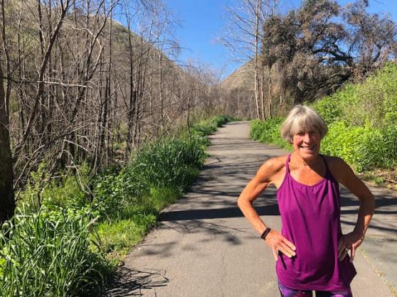
Part 1 concluded with the uncertainty whether my breakfast would return due to the rolling seas on our one hour high seas voyage from Ventura to Santa Cruz Island.

SC dock

At last, the metal framed, erector set dock at Scorpion Beach on Santa Cruz comes into view.  Victory is in sight as my oatmeal stays happily tranquil in my stomach.  None of the other 140 passengers is aware of my gastronomic triumph, but it’s those small victories we all embrace that get us through our own personal stormy seas.  (Chew on that.)

SC 3 H at start

Santa Cruz is the largest of the Channel Islands, 22 miles long and from 2 to 6 miles wide.   Click here to access excellent descriptions of these National Park hiking trails and maps of Santa Cruz Island.

SC 4 cliff

The cliff edges are indeed close to the trail

Debarking, we passengers are collected for some final instructions by our volunteer guide.  She tells us, We do not have fences, we have common sense.  Trails can be as close as ten feet to the cliffs.  And we later learn these bluffs aren’t just 70-80’ above the beach as we saw in Carpinteria, but hundreds of feet directly into the salty brine.

In conclusion, she reinforces that the boat leaves at 330P, not 335P.  The next excursion to Santa Cruz is not until Friday, three days away.  We get the message.

SC 3A cavern pt trail

Later I ask this volunteer what happens if someone does get left behind.  She tells me sometimes people do get lost on the island but not often.  The park service has some provisions and finds a place for the errant ones to spend the nights.  From what we can see, they are not deluxe accommodations.

SC 3B H at cavern point

From the Cavern Point Loop Trail

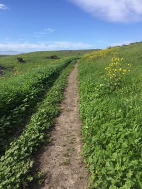
Ready to rock and roll on the trail, we choose to climb to the moderately rated Cavern Point Loop Trail along the bluffs of Santa Cruz.  Within feet of the edge of the rocky cliffs, we are taken by what we imagine Ireland would be like.   Green on green meadows, beautifully highlighted by yellow flowers; unfortunately, we learn they are invasive.   We were told that with the previous years of drought the landscape had turned a gray brown.  Today, we, with about fifteen others, have miles of trail to ourselves.

SC 3C trail with yellow flowers

The meadows of grass are nearly treeless so our view is for miles.  At times, the trail is wide enough for two, and soon turns into the just slightly larger Potato Harbor Road.  Hardly a road, hardly a fire road, it is a delightful walk in the fields of emerald green.

On the North Bluff Trail, we meet Kirk and Alison, who ask us to take their picture.  Soon learning that today, Valentine’s Day, is their second anniversary, we feel a good vibe with them; but I forget to give them my business card with info about my blog. Damn, I’ve got to be quicker.

SC 4C potato harbor coral

Potato Harbor

Two plus miles in, we are high above Potato Harbor.  Though we have no access to the harbor below, we do see coral blue water, something out of Hawai’i or the Caribbean.

With no comfortable place for lunch, we hike back through the meadows to the campground with picnic tables, bathrooms, and potable water.   We day hikers know the value of sitting at a picnic table for lunch rather than hunched over on a rock or log.  Of course, we are soft and these accommodations suit us to a T.

SC 4F trail

As we leave, the aforementioned Kirk and Alison arrive to take our picnic table for their lunch.  Playfully, I point out that we warmed it up for them; not missing a second chance, I hand them my business card, mentioning my Saturday blog.  I add that this hike will be reported on in the weeks ahead.  They smile broadly; say they’ll look it up.

Funny, I hear from maybe 1 in 20 we connect with on the trail.  I get it that the trail encounter is a moment that fades once we are all back home with our routines, jobs, and network of friends.  (Not bucking the odds, they haven’t checked in… yet.)  That said, I am still in touch with Rob from Georgia who we met on the Appalachian Trail in Vermont.

SC 5 Smugglers cove trail

The Smuggler’s Cove Trail beyond the windmill

With two hours before we must be at the dock at 3P for the 330P departure for the mainland, Hannah and I look for more.   Climbing the rocky Smugglers Cove Trail above Scorpion Beach for more exercise on this beautiful sunny California day, we find a trail that is badly eroded by the recent rains, and awkward to walk on.   We persevere but wonder why.

SC 5B looking down from Smugglers

Scorpion Beach from the Smugglers Cove Trail

Taking a side trail to the bluff edge, we know that we can’t make it all the way to Smuggler’s Cove, 3.5 miles from the trailhead.  Hyper-cognizant of the departure time, we are aware how much we prefer a shower, a glass of wine at our cottage rather than the unknown accommodations here on the island for three nights.

SC 5A looking down from Smugglers

The view to the visitor center at Scorpion Beach

Like so many others, we arrive a good hour before the Island Explorer leaves the dock.  Weary from nearly eight miles of hiking, I plop down on the bench in the stern of the Island Explorer for the mellow trip back to Ventura Harbor.

SC 6 H by boat at end

Made the 330P departure.  Last ones on.

On our return, Captain Luke slows the boat, having found a pod of Pacific gray whales heading north in the Channel.   Within a hundred yards of these glorious mammals, we see the blows of six to eight whales; they then arch their backs, bursting out of the water.  This is all followed by their tails flipping up as they re-submerge.  Later, after the final blows, as if choreographed, six whales wave good bye in unison with their tails.  It’s nature poetry in motion.

SC island packers

On the ride home, which is incredibly smooth as promised, Hannah gets the brilliant idea to have the captain acknowledge Alison and Kirk’s anniversary.  Having passed the information on to the captain, we finally hear the announcement as we head into the harbor.  Beaming as the proud parents of this fine idea, we wonder if they’ll guess it is us.  We do hear clapping above on the second deck.

Hannah and I are just not “going out in any kind of boat” people, be it in lakes, rivers, or oceans.  But we both would say don’t miss this boat trip.  You have the trifecta of bluff hikes on unsullied terrain, whales, and dolphins on the ride to and from Ventura.  No race track could beat that winning combination.