This is Michael. Can I help you?
Michael, this is Dan in room 110. There are loud noises coming from the room above us. Can you do something about it?
I’ll check on it immediately.
My iPhone lights up at 1:44A on this Sunday morning, our first night in California with some serious jet lag. The voices of partying young women coming through the ceiling have awakened me again. And the women don’t sound like they are going to bed anytime soon. Then, not a minute later, I hear a knock on a door above me. And then it’s quiet.
Thank you Michael, I whisper. Peace in the valley.

Usually our experiences in motels are positive. We get free breakfasts and always have a queen bed or more. I do travel with ear plugs for just such occasions, but they are no match for these exuberant weekend voices. Hoping noisy people in the next room will just stop has never proved to be a winning strategy for me.
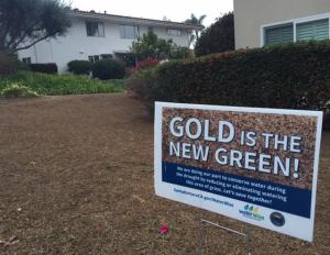
Sleeping til 530A (it is 830A in Maine), Hannah and I walk before sunrise through the sleepy coastal enclave of Santa Barbara. Despite this year’s El Nino, the lawns are still brown. As far as lawns go, gold is the new green.

Jasmine Cottage VRBO in Summerland, CA
Coming to Santa Barbara to escape winter in Maine and hike the bluffs and mountains along the Pacific coast, we make connections this Sunday morning with locals at the Unity of Santa Barbara spiritual community. Later we check out a VRBO (Vacation Rental by Owner) home in Summerland, just four miles south of Santa Barbara, to see about being snowbirds (i.e., renting a house for a month next winter in the area).

Despite the threatening skies and forecast of mid-afternoon rain, we are determined to hike a bluff trail just north of Goleta, near the campus of the University of California, Santa Barbara.
Using the description for the four mile Goleta Beach hike in Day Hikes on the California Central Coast as our guide, we find the trail a simple ten minute drive from Santa Barbara down The 101 south to UCSB and Goleta Beach.

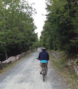
The bluff trail begins at Goleta Beach
Though Albert Hammond of It Never Rains in Southern California fame is usually right on, that’s not the case today. It’s mid-50s and light rain. Surfers and paddle boarders take on the swells from El Nino. Weather-wise, this year El Nino is win/win: rain in California in an effort to bust their five year drought and warmer winter temps and less snow in New England.

Leaving from the far end of the Goleta Beach County Park-ing lot with UCSB beaming in the distance, we will walk above the beach on a bluff and then around a campus lagoon.

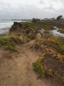
Immediately we notice that every fifty feet there is another sign cautioning hikers to stay back because waves are undercutting the bluffs. Looking left to the relentless ocean and then right to the UCSB campus just beyond the bluffs, we wonder what is going to happen to the university in the next generation or three? Check out this tree that is about to be given its last rites on the very edge of the cliff.

The trail through the cliff edge of campus is easy to follow with a road to our right. Noticing the non-native invasive ice plants dug into the cliff sides, we later learn that the second quarter at UCSB has just begun; the light rain seems to have kept the students inside and we have the trail to ourselves.

By the USCB campus
Skirting the UCSB campus towards the Marine Laboratory building, we see the campus lagoon. As we pass the lawns and interconnecting sidewalks of UCSB with its coeds and co-dudes, I realize a lifetime of wanting the college life no longer moves the needle for me.
When I was floundering as a teacher in Phoenix, AZ in my early 30s, I quit to return to Arizona State University to earn a Master’s in Exercise Physiology. I loved the easy going routine of taking a class or two a day, being a graduate assistant in the Human Performance Lab, and teaching intro tennis classes – all with time to train for the Fiesta Bowl Marathon. After three semesters, I earned my degree and still needed a real job: I returned to the classroom to teach middle school.
When I faltered again as a middle school teacher in Kittery, Maine in my late 40s, I bailed and returned to the University of New Hampshire for a PhD program in Reading and Writing Instruction. Breakfasts at Young’s Restaurant in Durham, NH, leading Exploring Teaching classes, supervising interns, all with time to complete my PhD without working a second job. Only years later did I realize our future son-in-law, Tip Rawding, was a student of mine during that time.

Having the required ticket punched to teach at the university (a PhD), for the next 12 years I returned to the comfort of the campus to teach at Eastern Connecticut State University and University of New England in Maine. All the while, my public school colleagues were on the front line and doing the heavy lifting.
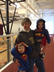
Supermen with their SuperOmi
But that college life train has left the station. I no longer swoon to be a student or teach at the university or, in fact, have the “want to” any more. As we navigate the bluff, the UCSB students I see today have my blessings, best wishes, and fond memories.
Of course, being a grandparent to Owen and Max and being able to travel in retirement has a lot to do with my letting go. Au revoir mon ami, l’universite.