

As a student teacher in fifth grade in the spring of 1970, I would walk from my Irish Hall dorm on the campus of Arizona State University to Mitchell School in Tempe, maybe a distance of a mile. I had no car and it was always sunny. I literally mean, it was always sunny for the entire semester in the Desert Southwest that spring semester. Our students had outside recess EVERY day.

As ones who lived for ten years in the Valley of the Sun (Phoenix Metro area), Hannah and I were used to a steady diet of 100+F degree days from the first of May until October. Day in and day out for those five months, we could count on lows in the 80s or 90s and highs always above 100F, often well above. It was not pretty. The summer weather is as consistent in the Southwest desert as a Steph Curry three pointer.
Weather consistency is not the case in our adopted state of Maine. Yesterday my UNH college buddy, Bill and I climbed the Beehive Trail at Acadia National Park in shorts and tee shirts in 68F of delightfulness. (See the list of categories to the left of the blog, click on Acadia National Park, and voila yesterday’s Beehive hiking blog will appear.)

Bill from Au Canada at Jordan Pond as our ride begins
This late April morning Bill and I wake in Bar Harbor to light rain with a freshening wind that puts a chill in the air. Welcome to the variability of Maine weather as today I will bike on the Carriage Roads of Acadia National Park on Mount Desert Island in zipoff pants, heavy sweatshirt beneath my jacket with Thinsulate gloves.

Carriage Road of Acadia National Park
Leaving our Best Western Acadia Park Inn after the morning rain abates at 930A, we drive the Park Loop Road past Eagle Lake and Jordan Pond without seeing another car. Though National Park Service has added parking to the Jordan Pond area, we have no problem finding a parking spot right in front of the classic Jordan House this preseason April.

Bundled up in late April
Unloading the bikes, Bill and I bundle up against the cold. Within two hundred yards, we are pedaling on the Carriage Road towards Jordan Pond itself. The downhill coasting we do at the outset belies what awaits us as we soon will make our way around the mountain.

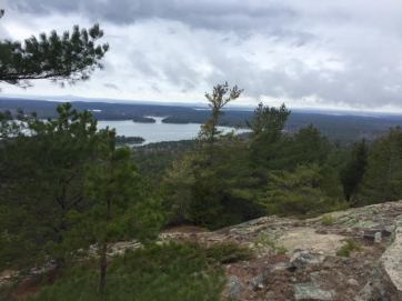
Jordan Pond from the Carriage Road
Paralleling Jordan Pond on the road, we ride side by side on the 16-foot-wide hard packed gravel Carriage Road with a steady climb. What must be annoying for Bill, I stop to take pictures as he pedals on. As a Canadian, he fits all the stereotypes: he’s a genuinely good guy, understanding, thoughtful, not full of himself, and he knows I’ll eventually catch up.
The signage is excellent for the Carriage Roads and especially for the “Around the Mountain” (i.e., Sargent Mountain) Loop that we will take. At sign marker 10, we head left and begin to climb as our pedaling becomes more labored. Thank heaven for my 21 gears and a winter of rocking the recumbent bike at our Coastal Fitness gym.

Mountain Bill on the far side of the mountain
As a steady, slow grind up the mountain, our conversation ceases. The name of the trail is “Around the M0untain,” but we become mountain climbers this still chilly morning. Soon my body produces heat as if I’m fueling a 1800s locomotive up over the Rockies; in time I de-bike and pack my jacket on my bike rack.
The day is raw and overcast with sprinkles here and light rain there as we are high above Frenchman’s Bay. But there is no getting around the beauty of the setting, especially without the chaos of the summer season.
Justly rewarded with a downhill, I ride the brakes lightly as the hard packed gravel is, well, still gravelly and could give way with a quick turn. We pass an athletic female runner with a Camelback water bag, then later a mountain racer zips by leaving us in the dust.
Somes Sound
The winding trail takes us high above Somes Sound with views to the mountains to the south and the Atlantic Ocean to the east. Descending easily on this dream ride, I put my gloves and jacket back on. Passing over many of Rockefeller’s stone bridges made from local granite, we later learn that the park has sixteen Carriage Road bridges that cross ravines or the motor routes through the park.

Waterfall of Waterfall Bridge (look hard, it’s there)
Soon we come upon another bridge and hear voices. Stopping to investigate, we spot the waterfall at the appropriately named Waterfall Bridge. Built in 1925, the Waterfall Bridge, which spans Hadlock Brook, is 125 feet in length and flares at the ends. A pair of viewing platforms jut out on either side to take advantage of the view.

Selfie of two UNH Wildcats at the waterfall
Upon returning to the Jordan House parking lot, we have had a 20 kilometer (12 miles American) ride “Around the Mountain” at a slow and steady pace over the past nearly two hours of spring chill on the coast of Maine. Finished with our ride, we head into town to explore and perhaps discover why the town is called Bar Harbor. And soon we will indeed find out why.
The view from Bridge Street in Bar Harbor to Bar Island
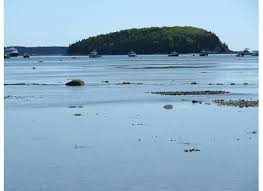
Seeing on our Acadia National Park Hiking and Biking Trail Map ($4.95 at the Visitor Center) that there is a trail from town to Bar Island just off shore, we work our way to Bridge Street. There we see a concrete ramp sloping into the bay, with Bar Island, maybe 400 yards in the distance. The tide is in and there is no way we are crossing without a boat. What gives? Where the h is the trail?

The rocky sand bar from Bar Harbor to Bar Island
Fortunately, an Anglo Rastafarian (perhaps I’ve jumped to that conclusion because he has dreadlocks) comes by and notices our perplexity. He tells us that for an hour and a half or two on either side of low tide, there is indeed a road to Bar Island that cars and walkers can cross. But once the tide comes in, one is stuck on the island for 8+ hours unless one wants to wade through what must be 40-degree water today.
Once called Eden, the town’s name was changed to Bar Harbor in 1918 because of the sand bar that goes to Bar Island. Bill and I light up with the possibility of exploring this island when we next visit; ever mindful of the low and high tides.
