

Arizona State Sun Devils, Hannah and Patty
We’ve come to the Northwest to hang out with our Arizona State (Harvard of the West) friends Patty and Kent and hike the trails of Washington and Oregon. Arriving by Alaska Air at 830 Saturday night on the Left Coast in Portland, it’s nearly 11P before we arrive at their place in McMinnville. It is 2A ET by our body clocks (wah-wah-wah), but when Patty’s homemade Sangria comes out, we are up for the next hour old-friending it.
 Sleeping six hours, we make our Sunday a lazy day of Patty’s loaded omelets and home fries, a 50 minute drive south to the capital of Oregon for the Unity of Salem service; followed later by naps and our traditional Mexican food out together.
Overnight, we are awakened by thunder on this the first day of June. Packing up early at 5A to beat the morning commuter traffic in Portland, we head north on route 99W on our way to the Washington side of the Columbia River Gorge; with the rain light and intermittent, our fingers are crossed that it will be at most light rain for today’s hike.

Breakfasting in Camas, WA
Driving east along the Columbia River, we set our sights on Camas, WA for breakfast. While we each have our two eggs, home fries, and a homemade biscuit at Smitty’s Family Dining, we see the rain kicking up from the passing vehicles. The day has got soggy written all over it.

Our rental car, VW Beetle
Thirty-one hundred miles from home in Maine and with just ten days to hike the Northwest, we know it’s going to take more than a little rain to keep us off the trail. The state of Washington tourism guide identifies the moderate-with-a-few-difficult-spots Hamilton Mountain hike as the premier trail in southwestern Washington. It’s a six mile round-trip with 2100 feet of elevation gain above the Columbia, the Gem of the Ocean.

Let the Hamilton Mountain Trail begin
With only one other car at the trailhead parking lot at 9A this workday Monday, we pack for rain. At the moment no rain is falling from the threatening cloudy sky of grey and black; we stow our ponchos in Hannah’s backpack for the climb and load my fanny pack with water, apples, and our favorite Nature Valley granola bars.

The leafy greenness of the Hamilton Mountain Trail
Under the forest canopy of old-gr0wth Douglas fir, we take to the sweetest of ascending trails. Here in the rainforest, the packed dirt path is covered with pine needles. For a mile it’s easy-peezy hiking with a steady climb. Used to being guided by white blazes when we hike the Appalachian Trail, we have no such markings here; that said, this well-maintained trail has signs and we never feel lost. The trail guide says a healthy dog, a child, or a senior citizen can climb to the top.

Hardy Falls
One mile into our three mile ascent, the Hardy Falls and the Rodney Falls are splashing treats that await us. Hidden by the trees on this south facing slope high above the Columbia River, the Hardy Falls teases rather blows us away.

Rodney Falls
Soon we are directed to the Rodney Falls which cascades into the Pool of Winds beneath. On slippery waterfall-splashed rocks, we are protected by a wire fence as we feel the spray from the thundering glory of this spring-fed waterfall.
 Choosing the direct assent of Hamilton Mountain, we pass a sea of ferns and giant green leafy plants which bracket our trail. Vistas to the Columbia River allow us to see a mile or two up and down the river despite the heavy overcast.
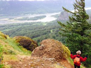
Looking west to the Columbia River
As the trail steepens, it turns rockier as we head into the interior and leave the wide river scenes behind. Though it has rained overnight, the trail is more dry than wet as we step carefully up the steeper parts.
As we approach the mountain top, the trail returns to the easy going dirt and pine needles. The wind is picking up and the chill makes me wish I had a sweatshirt. An hour and a half into our hike, we still have no rain and know we must be close to the top. The below video shows some of the mountain trail which turns out to be within 100 yards of the summit.

On faith we believe there are Cascades behind us
There we meet Tony and Mike and their black lab Bug who have just summited themselves. Agreeable guys in their thirties, we talk of past hikes at Mt. St. Helens; they encourage us to climb Beacon Rock (an Angel’s Landing-like promontory) directly across highway 14 from the Hamilton Mountain trailhead. Atop the mountain, the guide book promises panoramic views of the Cascades. If there are Cascades, we see none of them as we are smack dab in the middle of a cloud.

The Mighty Columbia
Feeling spunky and cocky that no rain has fallen, we decide to hike Beacon Rock after we finish Hamilton Mountain. Scooting down the mountain, almost skipping on the trail that at this point is rock-free, we still hope to beat the rain.
 Thirty minutes into our descent, we try to ignore the first drops of rain, hoping that they are just atmospheric anomalies. This is under the theory that if we ignore the raindrops, they won’t increase. But soon we hear the pings of rain on the leaves of the oaks. Though we are mostly under cover from the forest canopy, we decide not to risk getting soaked and slip on our bright Washington-evergreen ponchos. With two unexpected hours of rain-free hiking, we count our blessings.
The below video catches us at the Rodney Falls as the rain is picking up.

The trail narrows
The trail becomes slippery but nothing that we can’t handle by stepping carefully. The toll of the 2100 feet of elevation descent is making my knees bark. In a rash act of maturity (the first of two in the next twenty minutes), we choose not to hike the steep Beacon Rock today in the rain and save it for our return next week.

On the road to Packwood
At the trailhead, we fold our ponchos inward to keep the rain from soaking what else lies in our trunk, grab an apple and some strawberries, and check the map for the shortest way to Packwood, WA; where we have reservations at the Crest Trail Lodge, near the entrance to Mount Rainier National Park. Noticing roads on the map that are closed in the winter and appear serpentine with a capital S to the east of Mount St. Helens, we strike a blow for adult onset maturity and double back on highway 14, then north to drive 70 miles on I-5’s four high speed lanes; then a 6o mile straight shot on route 12 to Packwood.
Though this route is 70 miles longer, we high five it that we didn’t make the short-sighted decision to take to the hair-pinned, frost-heaved mountain roads of death. We just might be taking a peek into maturity’s big beautiful world.

Hey, I rented that same car (or maybe its brother/sister) in California 3 weeks ago! Good thing there were only two of you. I don’t remember our old VW bugs having that small a back seat or that heavy doors! But it ran just fine, didn’t it?
Sounds like a lovely trip! I’d like to go back to that area. Most of it I remember only as marathon driving on the way to the family cabin.
Yeah, those knees aren’t what they used to be!
Great blog post this morning Dan. And very nice videos as well. Also good to hear that adult ‘maturity” has set in without greatly restricting your fun. I would have bagged it just based on the rain forecast! You are inspirations to us all!